Kilimanjaro
My sister has decided to climb Kilimanjaro for her birthday. Sounds a bit arduous to me but that’s the sort of adventure she likes, so Happy Trekking!
And it’s a good excuse for me to go on about one of my favorite topics again, volcanoes!
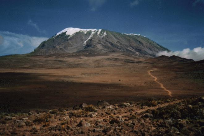
Kilimanjaro (Kilima Njaro or “shining mountain” in Swahili), is a large stratovolcano. In fact, it’s the tallest free-standing volcano on the earth’s land surface. It is located in Tanzania, Africa just south of the equator and is 5895 meters high at its highest point, Uhuru Peak. The volcano has a number of cones, the youngest of which is called Kibo. Kibo has a fairly large crater at the top. Some say Kilimanjaro is extinct, but in fact the volcano is still active and emits steam and gases from fumaroles in the crater. It has not erupted in the past 100,000 years or so. Mount Meru, just 70 kilometers to the west, last erupted in 1910.

This 3-D perspective view (which I got from Nasa’s Visible Earth web site) clearly shows Kilimanjaro's multiple peaks. The image was generated using topographic data from the Shuttle Radar Topography Mission, a Landsat 7 satellite image, and a false sky. Elevation exaggerated two times.

The image above is from Space Shuttle mission STS-97 on December 2, 2000 and it shows the glaciers and snow cap. The bits that look like cotton balls are actually clouds, the snow and ice is in the center, more streaky looking. As you can see from these images below from 1990, the mountain is losing its snow and glaciers.

Kilimanjaro is one of the volcanoes in the East African Rift Valley. The Great Rift Valley is the result of the ongoing separation of the African and Arabian tectonic plates in the north and rifting of the African plate in the south. The region has several volcanoes and lots of hotsprings that have formed over hotspots caused by the thinning of the lithosphere and upwelling of mantle plumes underneath. Lots of academic debate is going on in this area!
 Unlike the Great Rift Valley volcanoes, most stratovolcanoes form along subduction zones where one tectonic plate is diving down underneath another. When they erupt it is usually quite explosive. During active phases these volcanoes build up layers upon layers of lava, ash, cinders, etc into a steep symmetrical cone or cones and can get quite high. They erupt from vents which are conduits from a magma chamber deep inside the mountain.
When a stratovolcano becomes inactive for awhile or goes dormant, the softer material erodes away quickly, leaving the harder material which formed some of the layers and plugged up the vents. This erosion can result in landslides and even catastrophic collapses.
 Mount St. Helens is an example of a stratovolcano that exploded when its north flank collapsed and released the pressure that had built up inside. I was sleeping in on the Sunday morning in May, 1980 when it blew up and the bang woke me up. At the time, in my muddled half-asleep state, I thought someone had fired a cannon at the Haida festival in New West. Of course, in hindsight that’s a pretty silly idea as any kind of gunfire at a Haida festival would probably be highly offensive!
  The Big Guy and I didn’t know about the volcano until several hours later when we finally turned on the TV.
If the explosion is large enough the entire top of the volcano can be blown away, the magma chamber empties and what’s left of the mountain collapses inward leaving a caldera. An example of this is Crater Lake in Oregon, the collapsed remains of Mount Mazama.

Shield volcanoes are another type of volcano. I think I'll write about them some other time. The Big Guy has supper almost ready...
posted by Roewan @ 3:49 PM
0 comments
![]()

0 Comments:
Post a Comment
<< Home