Kilimanjaro Climb Part 1 - Introduction
This spring my sister, Alice, felt that she needed to do something special to mark the event of her 50th birthday and she decided to do the Mount Kilimanjaro climb. At my urging, she's handed over some of her photographs and notes and I'll be attempting to give you some idea of what the climb was like in this blog. Her words (with the bare minimum of editing by me) will be in italics. My words will be in the usual font I use for these blog entries.
Alice begins her Climb journal:
March 28
I'm sitting at Vancouver airport waiting for my KLM flight to Tanzania to board. I'm starting to feel more relaxed and less ill. I've been fighting a flu for nine days and it has turned me into a bear as I imagine my trip to Africa ruined.
I'm packed with a 27-pound porter load, 14 pounds in my backpack and another duffle bag filled with used clothing and my safari gear.
I had a great good-bye with Greg and the kids. All is well...
In eight minutes my plane reached 21,000 feet and it's -23° C outside.
Alice is a runner, an experienced hiker and has also done some rock climbing and mountaineering, including a trek to Everest Base Camp, whereas I am a somewhat sedentary ex-computer geek so it's going to be a bit of a stretch for me to really do justice to her experiences on Kilimanjaro.
With that said, I'll just forge ahead and if I mess up the account too badly I'm sure she'll let me know. I can always go back and edit these blog entries even after they're posted.
To begin, here's some background about Kilimanjaro.
Mount Kilimanjaro in Tanzania is the tallest mountain in Africa and the tallest freestanding mountain in the world. "Freestanding" basically means that it's not part of an already elevated mountain range such as the Himalayas.
The mountain is almost unique in that it is one of the few high mountains in the world that one can climb with little mountaineering experience. However, the challenge should not be underestimated, summiting Kilimanjaro requires good health, fitness and stamina. Climbers risk altitude sickness.
Kilimanjaro is a volcano, now dormant, that rises from equatorial forests at its base (elevation approx 2000 meters) to its summit at 5895 meters. It still has glaciers at its peak, although they are disappearing in today's global warming trend. Kilimanjaro climbers hike for 90 to 100 kilometers, depending on their route, ascending almost 4000 meters through cultivated farm land, tropical Montane (coniferous cloud forest), heath and moorland, alpine desert, snow fields and ice cliffs, all very close to the equator. Climbers need to be prepared for a wide range of weather conditions during the climb, ranging from tropical heat (30° C), high humidity and rain to bone-chilling cold down to -20° C.
The first nonlocal climbers to reach the summit of Kilimanjaro were Dr. Hans Meyer and Ludwig Purtscheller in 1889. It took them almost 6 weeks with a small army of porters, guides and advisors. Today, an average climber taking one of the main hiking routes makes the trek, up and back down, in six days.
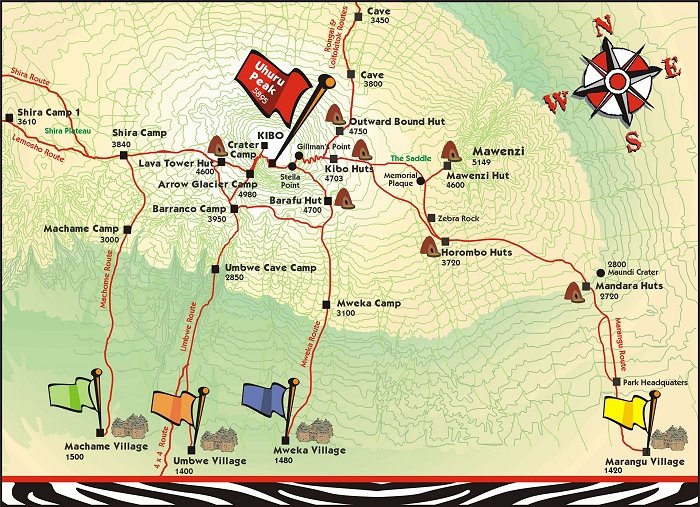
Alice chose the 6-day Machame Route, known as the most scenic route to the summit. The route ascends from the western side of Kilimanjaro and descends down the south face. The climb is not really technical, basically you hike and scramble to the top, but aids such as hiking poles and appropriate footwear are essential. Accommodation consists of tents. All climbers are accompanied by guides and porters.
The long rainy season in Tanzania runs from March to May so Alice's Kilimanjaro climb was free of the crowds that jam the routes and the summit during the dry seasons. On the other hand, the weather can be abysmal.
Alice: The six day climb was great! Our group consisted of Maria, two guides, six porters and me. We traveled the Machame Route, known to be more scenic and technical.
We were traveling during the off season, i.e., long rains, and had the Route to ourselves. We saw no other groups until summit day. Our campsites consisted only of us, whereas we heard there can be 300 people in a campsite during the high season.
The downside was the rain. We had a lot of rain and mist that was manageable for Maria and me, but very tough on the porters who are poorly dressed, carry heavy loads, and do all the camp setup and cooking. I became a master at keeping myself and most of my gear dry in the wet weather, as a summit attempt is a no-go with wet clothes.
This is a view of Mt. Kilimanjaro while on the Precision Air hop from Nairobi Airport to Kilimanjaro, a refreshing sight after a 9½-hour flight Vancouver to Amsterdam, a 9-hour wait in Amsterdam, and another 9-hour flight from there to Nairobi.

Enroute, Alice sends us a jet-lagged email from Schiphol airport:
I am in Amsterdam waiting for my flight to Nairobi. I'm feeling a lot better now that my trip is underway. My cold is starting to get better.
I'm so glad all the packing and getting ready is over.
My flight was uneventful but KLM is really not what it used to be. I've had the worst airline food ever!!!! My coffee did not even come with cream or milk. It was the powdered stuff!
Don't worry about me. I'm excited and you'll hear from me around April 6th or a bit sooner.
Eventually Alice arrived in Moshi, one of the small towns around Kilimanjaro where climbers make their base camp. She stayed at the Keys Hotel, a spot also popular with climbers.
Ok, now... my inner geek can't resist, I was playing with google maps and...
Click on these links for satellite views of Mount Kilimanjaro. In the first couple of maps look for the little grey spot in the bend in the northern border between Tanzania and Kenya.
1. View showing most of Africa
2. Zoom in to view of Tanzania
3. Zoom in some more to a view of Tanzania's northern border around Kilimanjaro
4. More zooming in to the mountain
5. Closest zoom possible on google maps (they really should ask the US military for their satellite images) of Kilimanjaro. If it was just a little closer you would be able to spot the trekking routes and campsites. Compare that image to this map. [6/23/06 Note: I think google's updated their images. You can zoom in on the summit much more closely now than when I originally wrote this entry. The trails are visible in many places.]
Part 2 of this Kilimanjaro Trip journal is here.
posted by Roewan @ 7:18 PM
1 comments
![]()

1 Comments:
That sounds like an amazing adventure.
Be safe.
Post a Comment
<< Home